
Trustindex verifies that the original source of the review is Google. Amazing works have used this company for 3 years, always delivers above expectations.Trustindex verifies that the original source of the review is Google. Fantastic work , very quick fast turn around , drawings are easy to understand , overall i'm very pleased and would highly recommend this serviceTrustindex verifies that the original source of the review is Google. Absolutely delighted with their service! Arrived thr next day and had the survey done after the weekend! We will definitely be using them again.Trustindex verifies that the original source of the review is Google. We recently hired Borna Surveys for measured building surveys on a couple of our properties, and we couldn’t be more pleased with the service. They promptly scheduled our survey for the very next day and arrived with a state-of-the-art laser scanner. The level of detail in the survey was truly impressive—far exceeding our expectations. Not only were they thorough and professional, but their pricing was also very reasonable, and they delivered results within the promised timeframe. We are extremely satisfied with Borna Surveys and will definitely use their services again in the future. Highly recommended!Trustindex verifies that the original source of the review is Google. AwesomeTrustindex verifies that the original source of the review is Google. We used Borna's setting out engineer to set out a new build house. Prompt, friendly and professional service from start to finish. Would highly recommend Thanks Karman! Colin Smith Project ManagerTrustindex verifies that the original source of the review is Google. We have hired john for some issues regarding boundery wall , really happey with his services and prompt response . Great work done overall thanks Muhammad YasirTrustindex verifies that the original source of the review is Google. Kamran came to set out on our site he was very professional and accurate. We were very happy with his service and will be using Kamran on other site in the future.
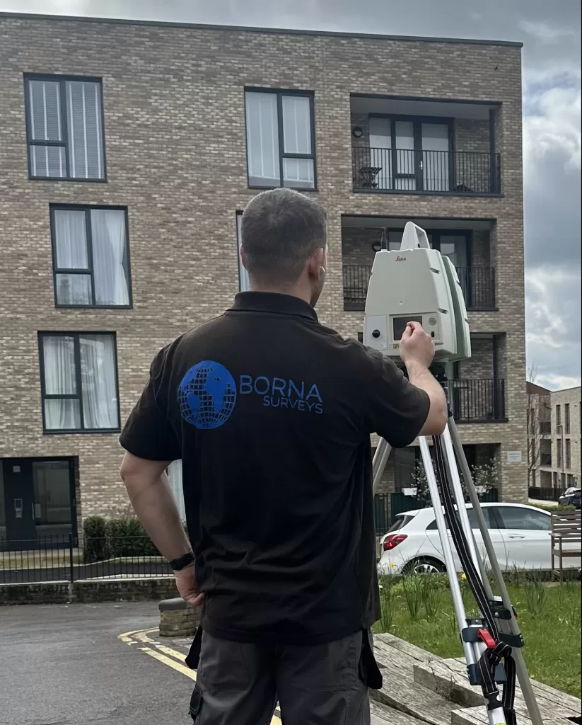
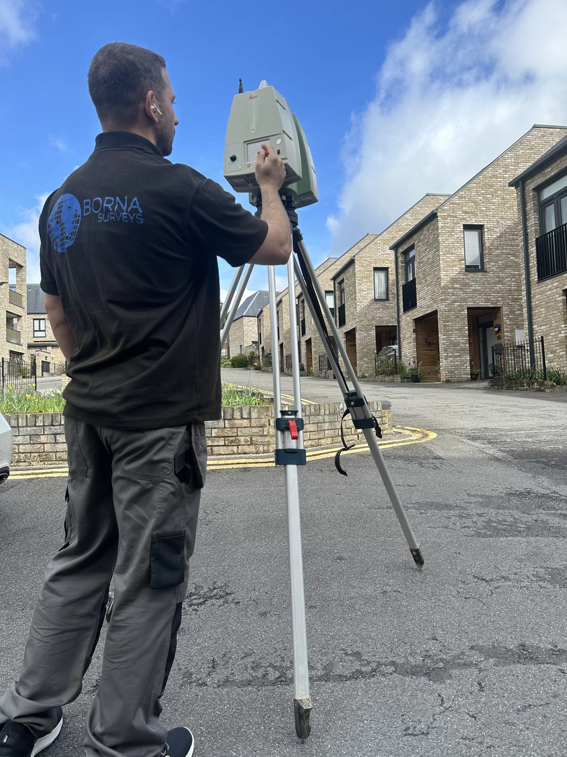
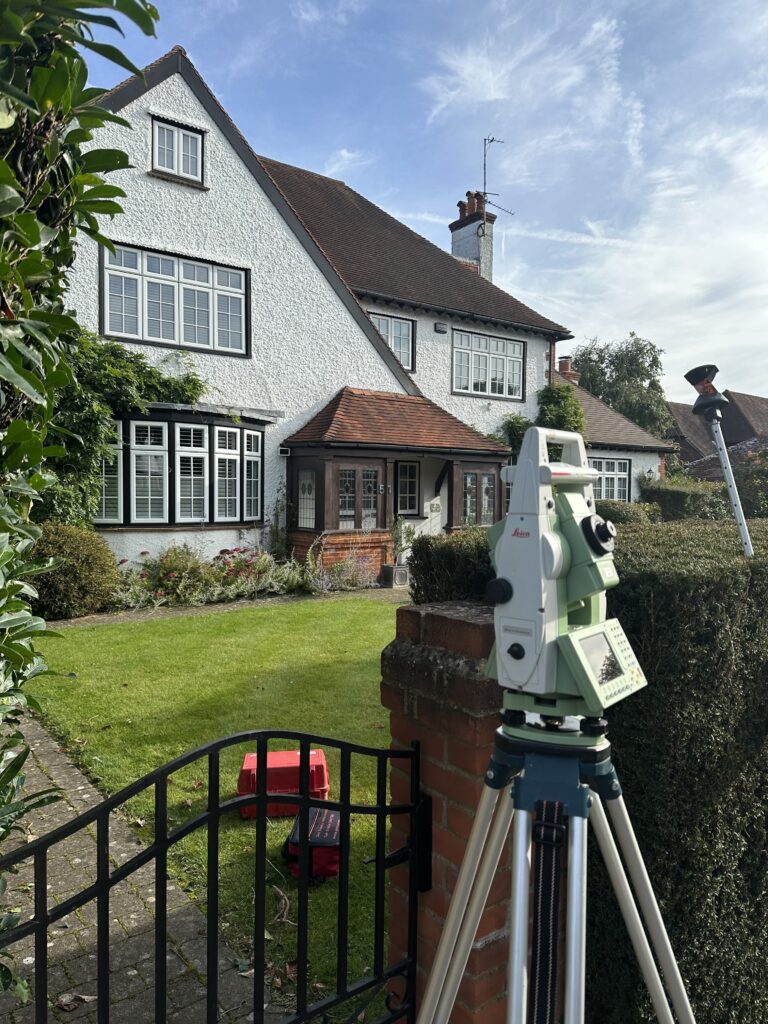
Our 3D Laser Scanning Surveys provide precise, accurate data to enhance construction and design projects.
What is a 3D Laser Scanning Service?
3D laser scanning services use advanced laser technology to capture highly accurate and detailed spatial data of objects and landscapes. Additionally, this method ensures exceptional precision in measurements, which significantly reduces the margin of error. Not only does it streamline the data collection process, but it also enables quicker analysis compared to traditional methods. As a result, laser surveying is invaluable for mapping terrains, structures, and environments. Consequently, it delivers comprehensive, precise information crucial for architecture, engineering, construction, and industrial applications. Furthermore, this technology facilitates seamless integration into CAD and BIM systems, making it an essential tool for project planning and design. Ultimately, it boosts both efficiency and accuracy across all stages of project execution.
According to the latest guidelines on 3D scanning technology, these methods are crucial for accurate measurements.
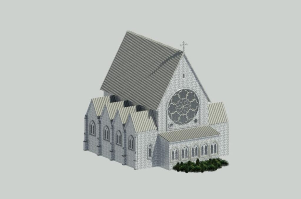
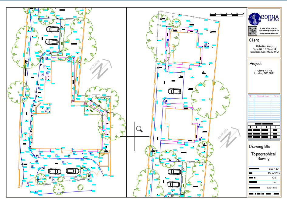
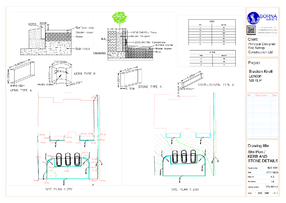
Comprehensive Scan to CAD Services
Discover the unmatched precision of Borna Surveys’ laser scanning services, enriching your building projects with advanced capabilities. In addition, our offerings encompass Scan to CAD, delivering meticulously crafted floor plans, elevations, site plans, and cross-sections in DWG or PDF formats; furthermore, these deliverables facilitate seamless integration into your existing workflows. Immerse your projects in accuracy with As-built 3D models, seamlessly compatible with BIM, Revit, CAD, and SketchUp.
As-Built 3D Models for Accurate Planning
We deliver precise as-built 3D models compatible with BIM, Revit, CAD, and SketchUp, enabling accurate planning and execution of your projects.
Photo-Realistic Visualizations
Enhance your presentations with our photo-realistic visualizations, achieved by merging scan data with HDR photography for lifelike representations.
BENEFITS OF 3D LASER SCANNING SERVICES
Precision Deliverables
Get detailed and dependable 3D point cloud data, Scan to CAD, and 3D BIM Models from laser scanning experts, including surveyors and technicians.
Quick & Effective Completion
We promptly generate your specified outcomes using streamlined procedures and extensive expertise in the laser scanning sector.
ADVANCED TECHNOLOGY
Leveraging cutting-edge 3D laser scanning technology, we capture accurate data at a rate of up to 1 million points per second. Utilize top-tier equipment for the project-specific level of detail you require.
Experienced Staff
Our skilled team consistently prioritizes excellence in your construction project. Our adaptable approach ensures an optimized measured survey service with minimal interruptions.
FAQ
Laser scanning is a technology that captures precise three-dimensional data of objects or environments. however, at Borna Surveys, our laser scanning services offer comprehensive and accurate data, enabling better project planning, design, and analysis, ultimately saving time and costs.
Laser scanning provides faster and more detailed data collection compared to traditional survey methods. It captures millions of data points in a short time, enhancing accuracy and efficiency. Borna Surveys leverages this advanced technology to deliver superior results for your projects.
Laser scanning is versatile and applicable across various industries such as construction, architecture, engineering, and infrastructure. Borna Surveys tailors its laser scanning services to meet the unique needs of clients in these sectors, ensuring optimal results for diverse projects.
Measured survey costs vary based on property size, complexity, and location. For an exact price, individuals can request a quote tailored to their specific project needs. Contact us to receive a personalized estimate for your measured survey requirements. For get a quick quote click Here.
Absolutely. Laser scanning is scalable and adaptable, making it suitable for projects of all sizes. Whether you’re working on a small construction site or a large infrastructure project, Borna Surveys can customize laser scanning solutions to meet the specific requirements of your project.
Borna Surveys provides laser scanning data in various compatible formats, facilitating seamless integration into common design and modeling software. Our team also offers support and consultation to help clients effectively utilize the laser scanning data for their specific workflows and project goals.
Why Choose Borna Surveys? We Guarantee
Accuracy and Precision:
We prioritise accuracy in every aspect of our work, ensuring that our clients receive reliable survey data for informed decision-making.
Timely Delivery:
Our efficient processes and advanced technology enable us to deliver survey results promptly, meeting your project timelines and deadlines.
Customised Solutions:
Recognising that each project is unique, we tailor our services to meet your specific requirements, providing personalised solutions that add value to your endeavors.
Experienced Professionals:
Our team of seasoned surveyors brings years of industry experience to the table, guaranteeing a high level of expertise in every project we undertake.
Client-Centric Approach:
We prioritize clear communication and collaboration, working closely with our clients to understand their needs and deliver results that exceed expectations.
Our Services


Get in Touch
phone
+44 800 054 1112
Business Hours
- Every day 9am – 8pm