
Posted onTrustindex verifies that the original source of the review is Google. Company did some great work for my wife and I after we were unhappy with other surveyors. Worth the price Thank you.Posted onTrustindex verifies that the original source of the review is Google. Great work, just completed boundary dispute and measure building survey. The team is very professional and diligent. I recommend this companyPosted onTrustindex verifies that the original source of the review is Google. I had a great experience working with Borna Surveys. They carried out a measured building survey for me, including detailed plans, sections, and elevations, and the quality of their work was excellent. The team were professional, responsive, and very easy to work with throughout the process. The survey was delivered on time and to a very high standard, which made a real difference to my project. I would highly recommend Borna Surveys to anyone looking for reliable and accurate surveying services.Posted onTrustindex verifies that the original source of the review is Google. I recently used Borna Surveys for a measured building survey, and I am extremely pleased with the service provided. Kamran was professional, reliable, and very easy to communicate with throughout the process. The survey was carried out efficiently, and the final drawings and report were detailed, accurate, and delivered on time. The quality of work and attention to detail were excellent, and the price was very reasonable. I would not hesitate to recommend Borna Surveys to anyone needing a measured building survey or related services.Posted onTrustindex verifies that the original source of the review is Google. Kamran, at Borna surveyors, was very professional, polite , clear and concise. I received a very detailed report within days at a very reasonable price compared to others. I fully recommend using this company especially for a boundary survey.Posted onTrustindex verifies that the original source of the review is Google. Fantastic Survey and Services, have used this company time and time and have proven themselves every time. Highly recommend.Posted onTrustindex verifies that the original source of the review is Google. Used for setting out survey for foundations and come back again for brickwork setting the pins. Fantastic service and on timePosted onTrustindex verifies that the original source of the review is Google. ⭐️⭐️⭐️⭐️⭐️ So professional wow! Job done so smoothly and efficiently. Thank you 🙏🏽Posted onTrustindex verifies that the original source of the review is Google. Amazing works have used this company for 3 years, always delivers above expectations.Posted onTrustindex verifies that the original source of the review is Google. Kamran was quick to respond and did the survey as requested
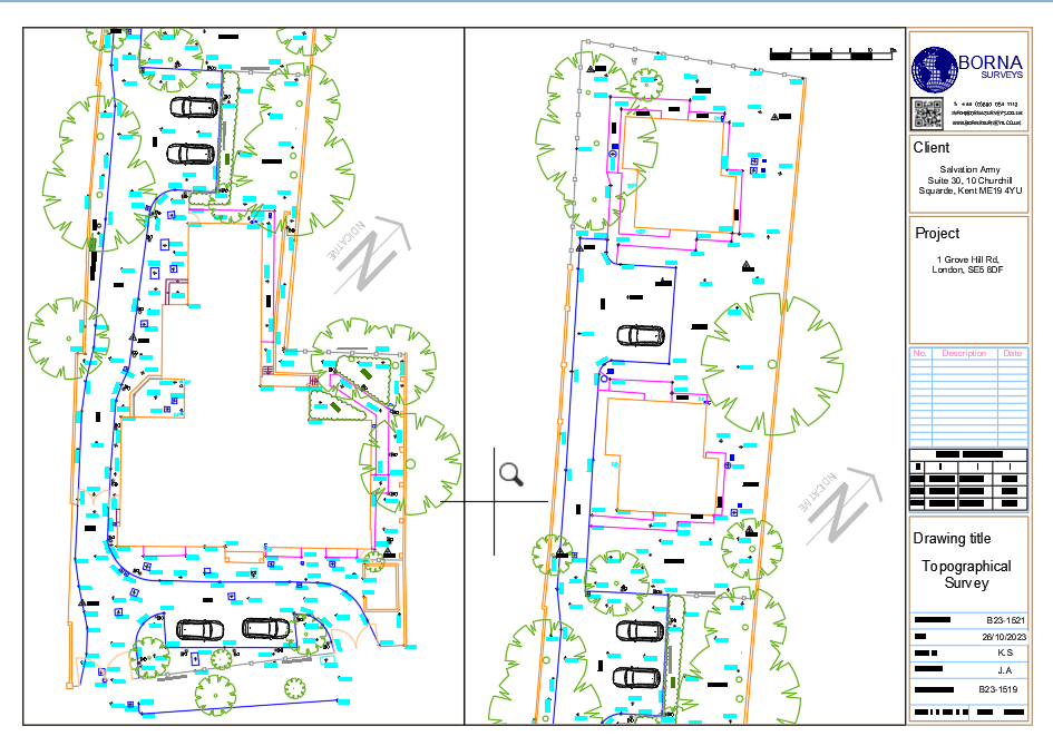
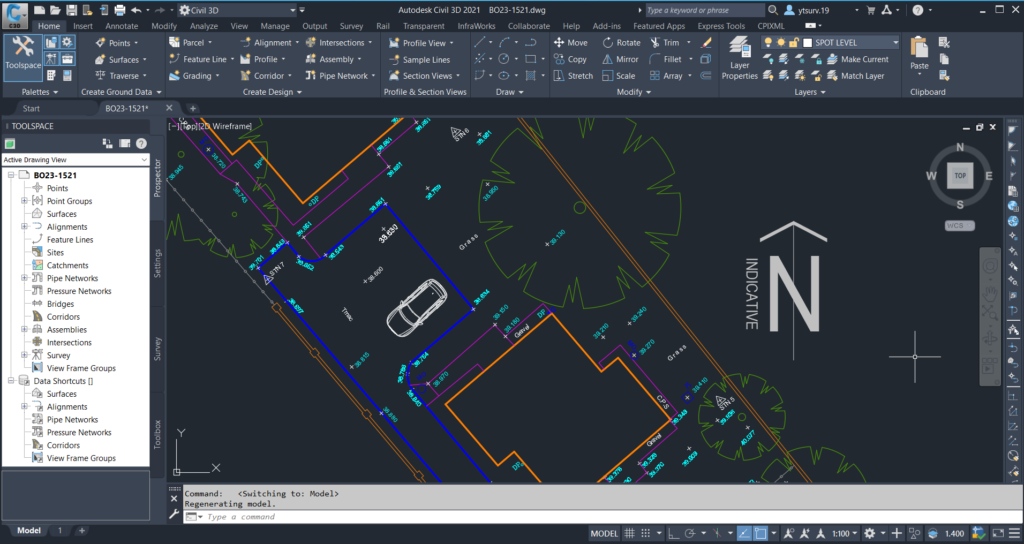
Location: 1 Grove Hill Rd, London, SE5 8DF.
DELIVERABLES:
2D AutoCAD Drawing
3D AutoCAD Drawing
Elevations and Floor Plans, scale 1:200
Key Highlights of Our Survey
Accuracy Beyond Measure:
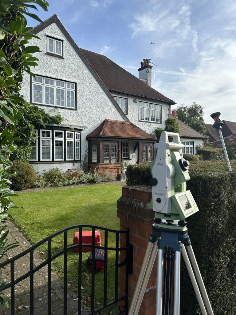
Accuracy Beyond Measure: Borna Surveys is dedicated to delivering surveys with unparalleled accuracy. Our state-of-the-art equipment and skilled professionals ensure that every detail of the landscape is captured with precision.
Thorough Mapping: .
The topographical survey conducted for 1 Grove Hill Rd involved a detailed mapping of the property, showcasing elevations, boundaries, and key natural features. This comprehensive mapping serves as a valuable resource for architects, developers, and property owners.
Timely Completion:
At Borna Surveys, we understand the importance of timelines in the fast-paced world of construction and development. We take pride in our ability to deliver high-quality surveys promptly, without compromising on accuracy.
FAQ
A topographical survey meticulously maps both natural and artificial features of a land area, including contours, elevations, vegetation, and structures. This comprehensive data is crucial for informed design and planning processes in various fields such as architecture, engineering, and environmental management.
A topographical survey meticulously maps both natural and artificial features of a land area, including contours, elevations, vegetation, and structures. This comprehensive data is crucial for informed design and planning processes in various fields such as architecture, engineering, and environmental management.
A measured survey is a precise documentation of a building or land’s physical dimensions and features. Conducted by professionals using instruments like tape measures or laser scanners, the survey provides accurate data for creating architectural plans and 3D models. It is essential for design, construction, and property assessments, ensuring reliable information.
Our measured survey services can be booked within 48 hours of contacting us. For properties up to 7 rooms, please note that we typically require one full day to ensure a thorough and precise survey.
Measured survey costs vary based on property size, complexity, and location. For an exact price, individuals can request a quote tailored to their specific project needs. Contact us to receive a personalized estimate for your measured survey requirements.
To prepare for your survey, ensure unobstructed access to all areas, provide relevant documents, and communicate specific requirements or concerns with the surveyor in advance.
We provide measured survey services throughout the UK, covering various locations to meet your property documentation needs accurately and efficiently.
Why Choose Borna Surveys?
Accuracy and Precision:
We prioritise accuracy in every aspect of our work, ensuring that our clients receive reliable survey data for informed decision-making.
Timely Delivery:
Our efficient processes and advanced technology enable us to deliver survey results promptly, meeting your project timelines and deadlines.
Customized Solutions:
Recognizing that each project is unique, we tailor our services to meet your specific requirements, providing personalized solutions that add value to your endeavors.
Experienced Professionals:
Our team of seasoned surveyors brings years of industry experience to the table, guaranteeing a high level of expertise in every project we undertake.
Client-Centric Approach:
We prioritize clear communication and collaboration, working closely with our clients to understand their needs and deliver results that exceed expectations.
Our Services


Get in Touch
Phone
+44 800 054 1112
Business Hours
- Every day 9am – 8pm