
Posted onTrustindex verifies that the original source of the review is Google. Company did some great work for my wife and I after we were unhappy with other surveyors. Worth the price Thank you.Posted onTrustindex verifies that the original source of the review is Google. Great work, just completed boundary dispute and measure building survey. The team is very professional and diligent. I recommend this companyPosted onTrustindex verifies that the original source of the review is Google. I had a great experience working with Borna Surveys. They carried out a measured building survey for me, including detailed plans, sections, and elevations, and the quality of their work was excellent. The team were professional, responsive, and very easy to work with throughout the process. The survey was delivered on time and to a very high standard, which made a real difference to my project. I would highly recommend Borna Surveys to anyone looking for reliable and accurate surveying services.Posted onTrustindex verifies that the original source of the review is Google. I recently used Borna Surveys for a measured building survey, and I am extremely pleased with the service provided. Kamran was professional, reliable, and very easy to communicate with throughout the process. The survey was carried out efficiently, and the final drawings and report were detailed, accurate, and delivered on time. The quality of work and attention to detail were excellent, and the price was very reasonable. I would not hesitate to recommend Borna Surveys to anyone needing a measured building survey or related services.Posted onTrustindex verifies that the original source of the review is Google. Kamran, at Borna surveyors, was very professional, polite , clear and concise. I received a very detailed report within days at a very reasonable price compared to others. I fully recommend using this company especially for a boundary survey.Posted onTrustindex verifies that the original source of the review is Google. Fantastic Survey and Services, have used this company time and time and have proven themselves every time. Highly recommend.Posted onTrustindex verifies that the original source of the review is Google. Used for setting out survey for foundations and come back again for brickwork setting the pins. Fantastic service and on timePosted onTrustindex verifies that the original source of the review is Google. ⭐️⭐️⭐️⭐️⭐️ So professional wow! Job done so smoothly and efficiently. Thank you 🙏🏽Posted onTrustindex verifies that the original source of the review is Google. Amazing works have used this company for 3 years, always delivers above expectations.Posted onTrustindex verifies that the original source of the review is Google. Kamran was quick to respond and did the survey as requested
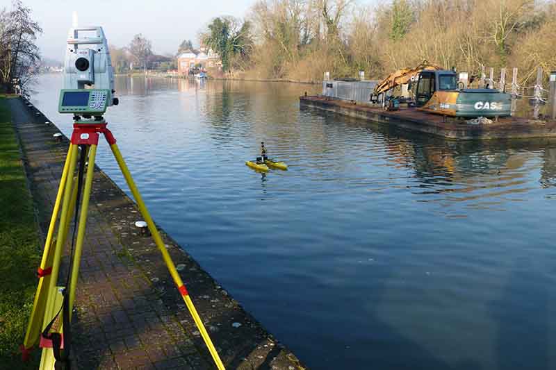
Welcome to Borna Surveys, your trusted partner in Hydrography Surveys, where precision meets the depths of water bodies. Our Hydrography Survey services are meticulously crafted to provide accurate and detailed information about the underwater terrain, ensuring the success of your maritime, offshore, or environmental projects.
Our Hydrographic
Surveying Services
Hydrographic Survey by Borna Surveys: Navigating Depths with Accuracy
Our hydrographic surveys use cutting-edge technology, such as sonar equipment and advanced GPS systems, to accurately measure underwater features. This is crucial for navigation, construction, and environmental studies. Whether you’re involved in marine construction, dredging, environmental monitoring, or offshore energy projects, Borna Surveys is here to deliver reliable data for informed decision-making. Learn more about industry standards from the International Hydrographic Organization (IHO) or explore the NOAA’s guidelines on hydrographic surveys.
Key Features of our Hydrographic Survey Services:
State-of-the-Art Technology:
Borna Surveys employs advanced sonar technology, bathymetric surveys, and remote sensing to capture high-resolution data of underwater features. Our equipment is designed to provide accurate depth measurements and detailed mapping of the seabed.
Navigational Safety:
Accurate charts and maps are essential for safe navigation. Our Hydrography Surveys contribute to navigational safety by identifying underwater hazards, shallow areas, and providing precise depth information to mariners and project planners.
Environmental Monitoring:
Hydrography Surveys by Borna play a crucial role in environmental assessments. We monitor changes in water bodies, erosion patterns, and sedimentation, providing valuable data for environmental management and conservation efforts.
Offshore Energy Support:
Whether you're planning offshore wind farms or oil and gas installations, our Hydrography Surveys assist in site assessments, ensuring that the underwater conditions are thoroughly understood for safe and efficient project execution.
Customized Solutions:
Borna Surveys understands that each project is unique. Our Hydrography Survey services are tailored to meet the specific requirements of your project, providing you with the data and insights necessary to achieve success.
Why Choose Borna Surveys for Hydrographic Surveys?
At Borna Surveys, we combine expertise, innovation, and a client-centric approach to deliver Hydrography Survey services that exceed industry standards. Our commitment to precision, safety, and environmental responsibility sets us apart as a reliable partner for projects involving water bodies.
Navigate the depths with confidence. Contact Borna Surveys today to discuss how our Hydrography Survey expertise can contribute to the success of your project.
Flood risk mitigation modelling and hydrographic studies need accurate reliable data supplied in recognisable formats, from CAD section drawings to text files. Borna Surveys have produced many hundred’s of long & cross sections for prestigious clients and major infrastructure projects in the UK.
FAQ
Hydrography is the science of measuring and mapping bodies of water. Borna Surveys specialises in Hydrography services, providing accurate data on water depths, underwater features, and navigational hazards. This information is vital for various projects, including marine construction, dredging, and environmental assessments.
Borna Surveys utilises advanced sonar technology, bathymetric surveys, and remote sensing to collect precise data on water features. Our Hydrography services employ state-of-the-art equipment to map the underwater terrain, ensuring comprehensive and accurate results for clients.
Absolutely. Borna Surveys’ Hydrography services are instrumental in coastal and shoreline management by providing critical data on coastline changes, erosion, and sedimentation. This information aids in developing effective strategies for shoreline protection and sustainable coastal development.
Hydrography surveys are essential for a range of industries, including maritime, offshore energy, environmental monitoring, and infrastructure development. Borna Surveys tailors its Hydrography services to meet the specific needs of clients in these sectors, ensuring precise and reliable data for their projects.
Hydrography plays a crucial role in safe navigation by providing accurate charts and maps of water bodies. Borna Surveys’ Hydrography services ensure that navigational hazards, underwater features, and depths are precisely documented, enhancing the safety of maritime activities and infrastructure development in water environments.
Why Choose Borna Surveys? We Guarantee
Accuracy and Precision:
We prioritise accuracy in every aspect of our work, ensuring that our clients receive reliable survey data for informed decision-making.
Timely Delivery:
Our efficient processes and advanced technology enable us to deliver survey results promptly, meeting your project timelines and deadlines.
Customised Solutions:
Recognising that each project is unique, we tailor our services to meet your specific requirements, providing personalised solutions that add value to your endeavors.
Experienced Professionals:
Our team of seasoned surveyors brings years of industry experience to the table, guaranteeing a high level of expertise in every project we undertake.
Client-Centric Approach:
We prioritize clear communication and collaboration, working closely with our clients to understand their needs and deliver results that exceed expectations.
Our Services


Get in Touch
phone
+44 800 054 1112
Business Hours
- Every day 9am – 8pm