
Posted on GoogleTrustindex verifies that the original source of the review is Google. Used for setting late notice and still came and got the job done will definitely be using again and passing to there number on to other clientsPosted on GoogleTrustindex verifies that the original source of the review is Google. I've had a great experience using Borna Surveys. The surveys are straightforward, easy to complete, and cover a variety of interesting topics. The platform is user-friendly, and I appreciate the clear communication throughout the process. Rewards are delivered as promised, making participation feel worthwhile. Overall, Borna Surveys is a reliable survey platform that offers a simple and enjoyable way to share opinions and earn rewards.Posted on GoogleTrustindex verifies that the original source of the review is Google. I’ve used Borna Surveys multiple times and have recommended them to family and friends. Their service is always professional, reliable, and great value for money. The team are brilliant to deal with, and I wouldn’t hesitate to use them again in the future.Posted on GoogleTrustindex verifies that the original source of the review is Google. Kamran at Borna Surveys was great to deal with—very efficient, quick to respond, and turned around both the quote and drawings promptly. Easy communication throughout. Would highly recommend.Posted on GoogleTrustindex verifies that the original source of the review is Google. I recently used Borja Surveys and was extremely pleased with the service provided. Karan was professional,reliable and very easy to communicate with throughout the process. Quality of work were excellent and very reasonable price. Would recommend Borna SurveysPosted on GoogleTrustindex verifies that the original source of the review is Google. We used Borna Survey for a measured building and boundary survey for our property. The job professionally completed. Highly recommended.Posted on GoogleTrustindex verifies that the original source of the review is Google. Really good support - prompt on picking up the enquiry and very quick to undertake the survey and report - we needed their help to verify the height of our building for BSA 2022 purposes and the service was very good - thoroughly recommendPosted on GoogleTrustindex verifies that the original source of the review is Google. Great experiance and really professionalPosted on GoogleTrustindex verifies that the original source of the review is Google. Company did some great work for my wife and I after we were unhappy with other surveyors. Worth the price Thank you.Posted on GoogleTrustindex verifies that the original source of the review is Google. Great work, just completed boundary dispute and measure building survey. The team is very professional and diligent. I recommend this company

Professional Photogrammetry Surveys Across the UK
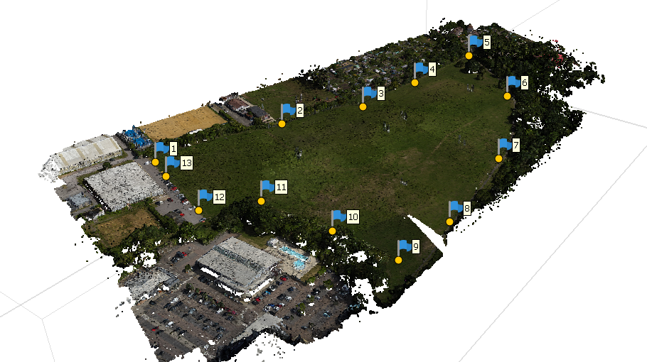
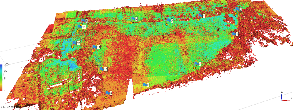
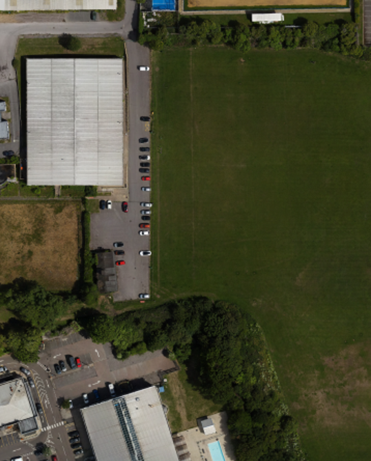
At Borna Surveys, we provide high-accuracy photogrammetry services using advanced drone and ground-based imaging technology. Photogrammetry is the process of capturing multiple overlapping photographs and converting them into precise 3D models, point clouds, orthophotos, and survey-grade measurements.
This innovative surveying method allows us to collect detailed spatial data quickly, safely, and cost-effectively, making it ideal for projects of all sizes across construction, engineering, architecture, infrastructure, and land development sectors.
What is Photogrammetry?
Photogrammetry is a surveying technique that uses hundreds or thousands of photographs taken from different angles to reconstruct a highly accurate three-dimensional representation of an object, structure, or site. Using specialised software, the images are processed to generate detailed digital models that can be measured, analysed, and integrated into CAD and BIM workflows.
The technology enables surveyors to capture large areas rapidly while maintaining excellent levels of accuracy and detail.

Our Photogrammetry Services
Borna Surveys delivers a comprehensive range of photogrammetry solutions, including:
Drone photogrammetry surveys
Aerial mapping and orthophoto generation
3D terrain modelling
Topographical surveys
Volume calculations for stockpiles and earthworks
Construction progress monitoring
Building façade surveys
Heritage and conservation documentation
Point cloud generation
BIM and CAD model support
Benefits of Photogrammetry
Fast Data Collection
Large areas can be surveyed in a fraction of the time required by traditional methods, reducing project timescales and site disruption.
High Levels of Detail
Photogrammetry captures millions of data points, producing highly detailed visual representations of sites, buildings, and structures.
Improved Site Safety
Data can be collected remotely, reducing the need for surveyors to access hazardous, difficult-to-reach, or operational areas.
Cost-Effective Solution
By reducing fieldwork time and increasing efficiency, photogrammetry often provides a more economical alternative for large-scale surveys.
Accurate Deliverables
Modern photogrammetry techniques can produce survey-grade outputs suitable for engineering, design, planning, and construction applications.
Applications of Photogrammetry
Photogrammetry is widely used across various industries, including:
- Construction and civil engineering
- Architecture and building design
- Land development projects
- Mining and quarry operations
- Infrastructure inspections
- Environmental monitoring
- Heritage and conservation projects
- Utilities and energy sectors
Deliverables:
Depending on project requirements, we can provide:
- Georeferenced orthophotos
- Digital terrain models (DTM)
- Digital surface models (DSM)
- 3D point clouds
- CAD drawings
- 3D mesh models
- Volumetric calculations
- BIM-compatible datasets
FAQ
A topographical survey meticulously maps both natural and artificial features of a land area, including contours, elevations, vegetation, and structures. This comprehensive data is crucial for informed design and planning processes in various fields such as architecture, engineering, and environmental management. For further information click Here.
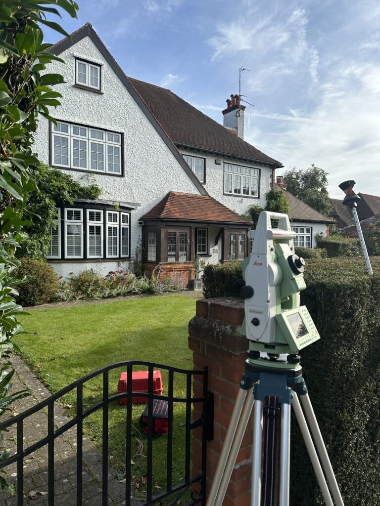
A laser scanning service employs laser technology to capture precise and detailed three-dimensional measurements of objects, environments, or structures, facilitating accurate data acquisition for purposes such as surveying, modeling, or documentation. For further information click Here.
Our measured survey services can be booked within 48 hours of contacting us. For properties up to 7 rooms, please note that we typically require one full day to ensure a thorough and precise survey.
Measured survey costs vary based on property size, complexity, and location. For an exact price, individuals can request a quote tailored to their specific project needs. Contact us to receive a personalized estimate for your measured survey requirements. For get a quick quote click Here.
A boundary dispute involves disagreements or conflicts between individuals, entities, or nations regarding the demarcation of physical or legal limits, often related to property, territory, or jurisdictional boundaries. For get a quick quote click Here.
We provide measured survey services throughout the UK, covering various locations to meet your property documentation needs accurately and efficiently.
Why Choose Borna Surveys?
Accuracy and Precision:
We prioritise accuracy in every aspect of our work, ensuring that our clients receive reliable survey data for informed decision-making.
Timely Delivery:
Our efficient processes and advanced technology enable us to deliver survey results promptly, meeting your project timelines and deadlines.
Customised Solutions:
Recognising that each project is unique, we tailor our services to meet your specific requirements, providing personalised solutions that add value to your endeavors.
Experienced Professionals:
Our team of seasoned surveyors brings years of industry experience to the table, guaranteeing a high level of expertise in every project we undertake.
Client-Centric Approach:
We prioritize clear communication and collaboration, working closely with our clients to understand their needs and deliver results that exceed expectations.